Dame’s Rocket and Bittersweet Nightshade

The botany books and Internet searches have helped to identify two more wildflowers in the backyard:  Dame’s Rocket (Hesperis matronalis) and Bittersweet Nightshade (Solanum dulcamara).  Dame’s Rocket is “prohibited” in Massachusetts due to its non-native invasive behavior.  (It that sounds bad, consider Connecticut’s designation of Dame’s Rocket:  “invasive and banned, e.g. illegal to move, sell, purchase, transplant, cultivate, or distribute”.  In some regions, including Europe, it is intentionally cultivated as a flower (with a lovely fragrance) in the garden, but “escaped” cultivation in Massachusetts, and is now an outlaw here.  We’ll keep an eye on it…

Bittersweet Nightshade has a striking yell0w-purple flower that looks almost man-made due to the brightness of both colors (maybe because they are complements).  However, this plant also is problematic in that its red berries are poisonous to people.  To make matters worse, the only one found thus far on our property is beside the brambles we think (or hope) are edible blackberries or raspberries.  Also one to watch and either remove or educate the family about.

Posted in Inventory | Comments Off on Dame’s Rocket and Bittersweet Nightshade

Chelidonium and Garlic Mustard

It’s Spring and flowers are beginning to bloom in the back yard.  Flowers provide one of the easiest ways to identify a plant.  I now know two of the plants that are filling up the woodlot by name.  One has a yellow flower with four petals and a yellow-orange sap when cut.  It’s Chelidonium majus.

Chelidonium majus

Chelidonium majus

The other plant is Garlic Mustard or Alliaria petiolata, a member of the Mustard Family.

Garlic Mustard

Wikipedia describes both as aggressive invaders (and both are non-native to the US).  Garlic Mustard, though edible, prevents other plants for using the same soil by releasing chemicals that prevent the growth of fungus needed by most other plants.  Chelidonium can be used to remove warts, but isn’t edible.

We decided to remove both species from the grounds.

In so doing, I discovered a third species of plant living there:  Poison Ivy!

Posted in Inventory | Comments Off on Chelidonium and Garlic Mustard

The model grows up to the rafters

Tonight I finished the framing all the way to the top of the house and added the back porch.  The below two images show the framing alone and then the structure with walls filled in.

Next, I’ll finish modelling the attic and the front porch.  With the house structure then complete, I can begin modelling the systems (electrical, water, heating, etc.).

Posted in Inventory | Comments Off on The model grows up to the rafters

Archaeology under the staircase

In the back corner of the front hall closet, I discovered a small square section of the wall that had been cut out and then nailed back together. I pried it out and peered into the space below the staircase (see below).

In addition to the pine cones cached by chipmunks or squirrels and the ancient spiderwebs long ago abandoned by spiders, I noticed a very dusty pile of paper.  It turned out to be a newspaper…the Boston Post published on August 1st, 1910.

This fragile piece of history supports the assertion from the real estate agency that our house was built in 1910.  Builders of houses with hollow Newell posts sometimes left rolled up construction plans inside the Newell posts — maybe because ours is solid rather than hollow, they instead left a newspaper underneath the Newell post!

Posted in Inventory | Comments Off on Archaeology under the staircase

Modeling the first floor’s structure

With the foundation and its framing in the SketchUp model, there’s something to hold up the first floor. So I’ve modelled the floor (including holes for heating vents), the framing of the exterior walls and the interior walls (see below). Since I’m not concerned with insulating the interior walls, I’ve modelled them as simple solids in SketchUp.  The exterior walls are structural and will need insulation, though, so I’ve taken the extra time to model their actual internal construction materials, starting with the two-by-four studs and the window and door framing.

To capture these elements of our house, I started in a corner and measured outward using a tape measure. Each time I had a few dimensions, I modelled them in Sketchup, starting from that same corner, and then, as I added walls or other elements, using those as new reference points for more measurements.

The framing is mostly hidden by the plaster interior, but in a few places, such as from within the cellar or where a pipe cuts into the wall in the cellar stair area, the framing is exposed. It looks like balloon framing, which means the studs that rest on the foundation (or a sill on the foundation) extend all the way up to the rafters in the roof. At this point, the model shows some of the studs going up that high, as  an initial reference. Once I have measurements for the windows on the second floor, I’ll know how to complete the framing on that level, and will extend all the studs as appropriate.

Once the floor, framing and interior walls were done, it was time for the “skin” that covers the framing — in our house, that’s lathe and plaster on the inside and an unknown on the outside, covered with a plastic siding exterior. I also added doors and windows, copied from Google’s 3-D Warehouse, and sized them to fit within the framing exactly.

I also modelled the main staircase in a separate Sketchup project using two photographs taken at different angles. When it was done, I moved it into the main project. The Newell post has some nice detailing that I included in the model, just for fun (shown below). Newell posts are sometimes hollow (ours is not) and builders would sometimes leave a rolled up set of construction drawings inside these hollow posts.

The next step will be to capture the second floor in the model.

Posted in Inventory | Comments Off on Modeling the first floor’s structure

Modeling our building using Google Sketchup

Our property’s value is split unevenly between the land and the house — the land is worth much more than the house. On paper, at least. To the people who live on the property, though, the house gets the lion’s share of attention and has many man-made systems to inventory. A useful way to understand all the systems is to capture them all in a computer model. I’ve chosen a free program from Google called “SketchUp” to model our house and maybe the surrounding land as well.

My home computing systems all run various flavors of Linux, and SketchUp runs on Linux thanks to “Wine”, the Microsoft Windows emulator. Using the Wine forums, I was eventually able to get SketchUp running on my Fedora Core 11 desktop. Aside from a small square mask surrounding the cursor, it seems to run very well. The square mask hasn’t been enough of an annoyance to prevent me from using SketchUp effectively.

To model our house, I began from the ground up, measuring our cellar’s dimensions down to one eighth of an inch precision using a 30′ tape measure. Once I had the dimensions, I drew simulated the concrete pad with a 3″ deep shape, then built up the fieldstone foundation walls, leaving openings for windows and doors. Next, I added the topography at the level where it touches the foundation. Finally, I modelled the stairs going up to the first floor and the stairs exiting through the storm doors. The resulting model appears below.

Next, I added windows from Google’s 3-D Warehouse and adjusted them to fit the foundation openings exactly.  Next came the chimney.  And then, by measuring the joists and girders that are all visible from within the cellar, I added the wood framing, as shown in the below image:

The ducts from the furnace will have to wait until the first floor is built, because I’ll use the measurements of the vent openings to properly model the ducts feeding them.  The laundry machines can also wait until the rest of the structure is modelled.

Posted in Inventory | Comments Off on Modeling our building using Google Sketchup

Rectifying local maps from 1876 and 1881

Barbara, our neighbor who has lived here for several decades, very kindly invited me to photograph two of her historic maps of this locality, one from 1876 and the other from 1881. The maps show roads, buildings and significant topographic features such as hills, aqueducts and railways.

I wanted to overlay the photographs of the old maps with current assessor’s parcel maps in order to easily see how the neighborhood has changed over time. The process of turning a photograph into a properly oriented map layer in a geographic information system is called “registration, rectification and warping” the image. The process involves comparison of points on the photographed map that are still identifiable on current maps. The process is to match individual pixels in the photograph to the coordinates of the real-world location that they correspond to on the current map. Whit these “ground control points” established, various software can then rotate, resize and “warp” the photographed map into approximate alignment with the current map. This enables both old and new to appear together or in a time sequence, without requiring any adjustment of the maps from one time period to another.

I decided to register, rectify and warp my two historic map images using a software package called the Geographic Resources Analysis Support System (or, GRASS), a free and open-source product with an active user and developer community. Unfortunately, although GRASS has many potentially useful and powerful capabilities, it was originally designed as a command-line tool (meaning users typed text commands, one at a time, to accomplish their work) rather than with more user-friendly graphical user interface. And, as still seems endemic in the free and open-source world, most documentation is oriented toward developers or users already familiar with the software’s core concepts. So, if I am able to figure out how to use GRASS to perform registration, rectification and warping, I’ll want to have some good directions available next time around; this blog post will serve that purpose. (Non-technical readers need go no further.)

The “raw” (unregistered, unrectified, unwarped) data in this example is the photo of Barbara’s historic map, which starts as a collection of pixels in rows and columns, each with a color value.  Seen together, they look like a map image. None of the pixels contain any coordinate information about the real-world location they represent. I need data about the same area covered by the historic map, but with real-world coordinates available. A public site with free assessor’s parcels for our town had exactly this in an ESRI shapefile format. I downloaded the parcel data for our town and stored it in a directory along with the images of Barbara’s maps (in PNG format).

Next, I opened GRASS, and was presented with a “Weldome to GRASS GIS” screen that included a button called “Location Wizard” for defining a new location. In GRASS, locations are user-defined regions and resolutions that influence how some of the GRASS commands work. To do much of anything in GRASS, you have to deine a location. So, I stepped through the screens provided by the wizard, including setting North, South, East and West coordinates for the region of interest and specifying a map projection. I left the grid resolution at the default of 1.0 and 1.0 and called the new Location “my_neighborhood”.

Next, at the same Welcome screen, I clicked the “Create mapset” button and named the new mapset “my_mapset”. For a task that only I will be performing (hopefully) once on a single dataset, mapsets aren’t very relevant, as their purpose is to manage multiple user edits of the same datasets. However, to avoid confusion or some unexpected GRASS requirements, I’m going through the motions.

Then I clicked the button saying “Start GRASS” and three windows opened: a terminal with a GRASS command line, a Layer Manager and a Map Display. In the Layer Manager window’s menu, I selected File -> Import Vector Map -> Multiple Import Formats using OGR. The resulting dialog window had multiple tabs, so I went through all of them and identified the parcel shapefile dataset in the “OGR datasource name” field and called it “parcels” in the “Name for output vector map” field. The shapefile’s projection already matched that of the Location I had just created.

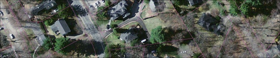
The parcels loaded as intended, which I was able to prove by clicking on the second icon from the left in the Layer Manager named “Load map layers into workspace” and then clicking the refresh icon in the Map Display window. The restul looked like this:

Thus far, the steps have established a data environment in GRASS that will provide real-world coordinate information about my neighborhood. Next comes the “raw” map photo from Barbara.

Posted in Inventory | Comments Off on Rectifying local maps from 1876 and 1881

Unearthing more old jars and bottles

Many more jars and bottles have followed the initial discovery, all coming from the same, but now larger, 3′ x 3′ section of the woodlot, shown below.

Excavation hole and some glass bottles and jars found there.

The small 3' x 3' hole in the upper left of the photo yielded these bottles and many more glass fragments.

Below are a few examples of unbroken glassware with design patents imprinted on their bases.

Two 1930's jars and one bottle

Two 1930's jars and a bottle dug up in the woodlot

The middle jar’s design patent is 80918, filed January 27, 1930, from Forest Hills, New York. The right bottle’s design patent is 85925, filed April 1, 1931, from Toledo, Ohio. The left jar’s design patent number is 93179, filed June 30, 1934, from Washington, Pennsylvania.

The majority of unbroken jars and bottles don’t display design patents on their bases, but those that do have, so far, all been patented in the 1930’s. So, the thinly buried pile of glass in that small area of the woodlot may have begun to accumulate in the thirties or forties.

Most of the unbroken bottles and jars don’t have design patents on their bases. However, the fantastic Historic Bottle Website will enable further dating of these pieces. An initial review suggests that most are from 1950 or later…

Posted in Inventory | Comments Off on Unearthing more old jars and bottles

Archeology in the backyard woodlot

Woodlot surface has small ridges and mounds covered by natural stick and leaf mulch

The woodlot has uneven, lumpy terrain compared to the rest of our site.

Jar discovered buried in the backyard woodlot.

Jar unearthed in the woodlot

The very back of our property is a small woodlot. While most of our land is level or gently sloping, the woodlot’s terrain is uneven and lumpy, as if the trees and vegetation grew on top of piles of trash. As it turns out, this may be exactly what has happened. Spending just a few hours digging into a 2′ x 2′ section of the soil has already uncovered at least 50 pounds of glass from broken bottles and jars. Some are still fully intact, like the one picturted to the right.

The bottom of this unbroken jar has raised characters saying, “DESIGN PATENT No 107801″ as shown in the closeup image below.

As defined by Wikipedia, a design patent “is a patent granted on the ornamental design of a functional item.” In hopes of learning more about when the glass might have been buried in our backyard, I searched the Google patent archive.

When searching for a typical patent in the Google archive, you just enter the numeric patent (e.g. “54321”) to find records of that invention. When searching for a design patent, however, you need to prefix the patent number with the letter “D”. So, searching for “D107801” returned the following “Design for a Packer Jar” patent record filed on November 11, 1937, and accepted on January 4, 1938.

D107801 US design patent

Design patent 107801

The three ridges broken by a zig zag diagonal ridge at the bottom of the patent design drawing match the actual ornamentation of the jar from our woodlot — it’s a match!

This design patent was filed by George Smith, Jr., “residing at Olean, in the county of Cattaraugus and State of New York, U. S. A.” in his capacity as “assignor to Olean Glass Company” a corporation also based  in Olean, NY.

This suggests that my jar is no younger than 1938, and, since the term of the patent is 7 years, it was probably bought by former inhabitants of our property at some point during the early 1940’s. Could there be a connection between dumping used jars in the backyard and World War II?

Posted in Inventory | Comments Off on Archeology in the backyard woodlot

What is neighborhood ecology?

What is the carrying capacity of my neighborhood? Beginning with my own property, I’m investigating whether my neighbors and I can sustain our lifestyles exclusively on the resources already in our neighborhood — sunlight, rainfall, flora, fauna, buildings, etc.

I’m beginning this investigation by inventorying my own property. The parcel is almost half an acre in area, and has six immediately distinct areas, as labelled in the aerial photograph below: front lawn, structure, driveway, back lawn, pine tree stand and woodlot.

Aerial photograph of our property with a dashed parcel boundary and area labels

My plan is first to inventory this property quite comprehensively, and on the basis of what I find, to then design the site’s retrofit, implement the design and then monitor results.

In his book, Gaia’s Garden, A Guide to Home-Scale Permaculture, 2nd Edition, Toby Hemenway provides a “designer’s checklist” of what to inventory (or, what Hemenway would call “observe”). It’s duplicated here:

  • History of the land: neighbors’ knowledge, library and public records, historical society, maps, photos, backyard archaeology (dig test pits);
  • Homeowners association and government activities: covenants, easements, yard waste pickup, recycling, herbicide spraying, water rationing, zoning and construction restrictions;
  • Nearby plantings that may affect your site (now or when fully grown);
  • Activities of neighbors that may affect design: noise, children, pets, visits, schools, industry, etc.;
  • Resources in the neighborhood: sources of organic matter, soil, and building materials such as sawmills, factories, food processors, stores, landfills, recyclers, nurseries, neighbors;
  • Utilities: power, phone, sewer and gas lines;
  • Areas of shade and sun, and how they change over the year;
  • Wind direction, intensity and change over the seasons;
  • Average and record temperature highs and lows, dates of first and last frosts;
  • Rainfall amounts and seasons, snow, hail;
  • Points of sunrise and sunset and their change over the seasons;
  • Topography, slope and aspect;
  • Rock outcrops, boulders, gravel;
  • Microclimates: cool, hot, wet, dry, sheltered and exposed spots;
  • Soil: drainage, heavy or light, sand or clay, rich or depleted, stable or slumping, compaction;
  • Water: flooding zones, drainage patterns, creeks, gullies, water movement during rain;
  • Views: good, bad and potential;
  • Location of structures on-site and nearby, such as houses, garages, fences and walls, and their effects on the surroundings: shade, runoff, windbreak, etc.;
  • Vegetation: species present, opportunistic or noxious plants, rare species and their state of health;
  • Animals: pets, native and introduced, pests, “scary” animals (snakes, spiders);
  • Traffic and its frequency, heavy or light vehicles, pedestrian traffic, bicycles;
  • Access: ease of bringing in materials, location of faucets, stairs, doors, garage, storage, etc.

Hemenway’s recommendation when taking this inventory is to “try to enter a Zen mind set or whatever it takes to simply observe without planning. Instead of ‘We can put a path here,’ make an observation statement such as ‘There is poor access to this area.'” His concern is that premature design decisions will “collapse the range of possibilities that remain.” I would add that observation and Zen detachment should also span an entire year, so the designer experiences the place in all four seasons before beginning to design.

Posted in Plan | Comments Off on What is neighborhood ecology?