 What is the carrying capacity of my neighborhood? Beginning with my own property, I’m investigating whether my neighbors and I can sustain our lifestyles exclusively on the resources already in our neighborhood — sunlight, rainfall, flora, fauna, buildings, etc.
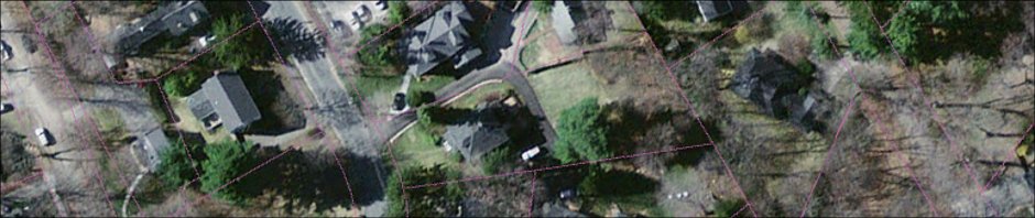
I’m beginning this investigation by inventorying my own property. The parcel is almost half an acre in area, and has six immediately distinct areas, as labelled in the aerial photograph below: front lawn, structure, driveway, back lawn, pine tree stand and woodlot.

My plan is first to inventory this property quite comprehensively, and on the basis of what I find, to then design the site’s retrofit, implement the design and then monitor results.
In his book, Gaia’s Garden, A Guide to Home-Scale Permaculture, 2nd Edition, Toby Hemenway provides a “designer’s checklist” of what to inventory (or, what Hemenway would call “observe”). It’s duplicated here:
- History of the land: neighbors’ knowledge, library and public records, historical society, maps, photos, backyard archaeology (dig test pits);
- Homeowners association and government activities: covenants, easements, yard waste pickup, recycling, herbicide spraying, water rationing, zoning and construction restrictions;
- Nearby plantings that may affect your site (now or when fully grown);
- Activities of neighbors that may affect design: noise, children, pets, visits, schools, industry, etc.;
- Resources in the neighborhood: sources of organic matter, soil, and building materials such as sawmills, factories, food processors, stores, landfills, recyclers, nurseries, neighbors;
- Utilities: power, phone, sewer and gas lines;
- Areas of shade and sun, and how they change over the year;
- Wind direction, intensity and change over the seasons;
- Average and record temperature highs and lows, dates of first and last frosts;
- Rainfall amounts and seasons, snow, hail;
- Points of sunrise and sunset and their change over the seasons;
- Topography, slope and aspect;
- Rock outcrops, boulders, gravel;
- Microclimates: cool, hot, wet, dry, sheltered and exposed spots;
- Soil: drainage, heavy or light, sand or clay, rich or depleted, stable or slumping, compaction;
- Water: flooding zones, drainage patterns, creeks, gullies, water movement during rain;
- Views: good, bad and potential;
- Location of structures on-site and nearby, such as houses, garages, fences and walls, and their effects on the surroundings: shade, runoff, windbreak, etc.;
- Vegetation: species present, opportunistic or noxious plants, rare species and their state of health;
- Animals: pets, native and introduced, pests, “scary” animals (snakes, spiders);
- Traffic and its frequency, heavy or light vehicles, pedestrian traffic, bicycles;
- Access: ease of bringing in materials, location of faucets, stairs, doors, garage, storage, etc.
Hemenway’s recommendation when taking this inventory is to “try to enter a Zen mind set or whatever it takes to simply observe without planning. Instead of ‘We can put a path here,’ make an observation statement such as ‘There is poor access to this area.'” His concern is that premature design decisions will “collapse the range of possibilities that remain.” I would add that observation and Zen detachment should also span an entire year, so the designer experiences the place in all four seasons before beginning to design.